Last weekend I decided not to stay at home and rest like I said I would but instead, decided to go and help out the Greater Phoenix Orienteering Club with their land navigation class. Twice a year, usually in the end of March/first of April and End of October, they have a Land Nav Class. So if you are ever lost in the wilderness, (which I have been) and you have a map and compass (which I didn't have when I was lost, so it really wouldn't have helped me out) you get find your way back to civilization. At any rate, if you love the outdoors and don't like sticking to trails like me, I highly recommend learning Map and compass skills.
Here are some pretty pictures I took while out Orienteering.
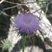
Desert Thistle
First is lovely picture of a Desert Thistle. I know thistles are weeds but it's still pretty plant.

Field of Wild flowers and cactus.

Tomatio (sp)
I'm not sure how you spell it, but this plant was shown to us by one of the students. She had tons of knowledge on plants said this plant's fruit is eatable. I did eat some of the berries and I'm still alive, yeah! The berries are the size of small jelly beans and if cut open have small seeds like tomatoes and has a taste very similar to tomatoes. Although I don't like tomatoes, and I could detect a hint of tomato flavoring, but it had more appealing taste.

Birds Nest in Cactus


Roblas Butte

Picketpost Mountain

And now for a little learning lesson on Orienteering.
Boxed Y
A Boxed Y is is term for a reentrant junctions. First a reentrant is the valleys of hills. Look at the picture below, and try to visualize where water would travel if it were raining hard enough to cause flash flooding.

Rivers and creeks are also examples of reentrant, but they are usually referred to as rivers and creeks. But if there was no water in the rivers and creeks then you have a reentrant. A reentrant junction is where two reentrants meet.
I've drawn where the reentrant junction are at.

On a Topographical Map all land features looks something like this. Land features are drawn in brown. Keep in mind this is not the same hill in the previous photos.

Can you see all the valleys? They are the represented by all the V's. The hills are more U shaped lines.

Now if you were to draw the reentrant junctions you have Y's like the the previous photo showed. The name Boxed Y comes from the way the contour lines box in the reentrant junctions.

Hope this helps a little and you found it entertaining.


No comments:
Post a Comment